
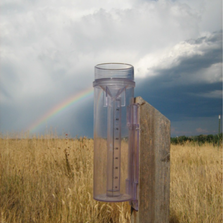
Let it rain! Citizen scientists all over the country are collecting the rain drops. And hail pellets. And snowflakes.
This is CoCoRaHS, the Community Collaborative Rain, Hail and Snow Network. Its mission is to increase the number of people having fun measuring precipitation. Rain, hail, and snow are all types of precipitation.
People like you measure and map precipitation. Kids can do it. Seniors can do it. Anyone who can find a clear spot to put up a rain gauge can do it.
Have you been frustrated when the weather forecast is wrong? Mountainous areas and microclimates make it challenging to know where the rain is going to fall. Rain is coming, but will it soak the land at the 3,000 foot level or the 300 foot level? That makes a big difference in who gets wet.
More data improves forecasts. And the best way to get more data is to have more people collecting it with rain gauges in their backyards.
It’s important that people are collecting data with the same equipment in the same way. CoCoRaHS helps with this. Each person that signs up is entered into a national network. They buy an inexpensive standardized rain gauge. The gauge is simple and tough. It has no moving parts.
Slideshows and short videos show you how to set up your gauge; how to measure rain fall; how to measure the size of hail; and how to measure snow depth and water content.
You submit data through a website or an app. You can enter as much or as little information as you want. You can report air temperature, whether it was windy when the precipitation began, whether the streams are low or high, and even the birds or animals you see.
The information is uploaded to a national map. You get instant gratification when you see your data on the map. You can compare your results to others’.
This information is important. The National Weather Service uses it to improve forecasts. That’s right. Your data can help make the forecast in your area more accurate! The data is also used by emergency managers, people tracking snowpack and river levels, and others.
It’s ok if you’re gone a lot and can’t read the gauge every day. You can enter a “multi-day accumulation” report when you get back.
You can still use interactive maps on the CoCoRAHs website even if you aren’t reporting precipitation.
What if you heard a storm was heading towards Montana where your brother lives? CoCoRAHs maps show you what people are reporting. You can see how heavy and widespread the rain is.
You can settle an argument with a friend about whether it snowed more in Palmer or in Buffalo. Go to the CoCoRAHs Station Explorer. You can even read personal notes about how precipitation is affecting a local area.
Only three stations in the Mat-Su have reported regularly over the last three months. These are station MS-30 in Palmer, MS-31 in Wasilla, and MS-22 in Chickaloon. Go to cocorahs.org to check them out.
And while you are there, sign up to be a CoCoRAHs observer. We can all use better weather forecasts.
Page 2 airs weekdays at 7 a.m., 9 a.m., 11:50 a.m., and 6 p.m.
Tune in at 89.7 in Palmer, 89.5 in Sutton, 88.3 in Chickaloon and Glacier View or online at bigcabbageradio.org.
Please support Page 2 News and Big Cabbage Radio. Become a member: Donate today at bigcabbageradio.org.
This Page Two article was reported by Kendra Zamzow and produced by yours truly, Lee Henrikson. If you have an idea for a Page 2 topic, please email us at page2@radiofreepalmer.org.
That’s it for today and the news on Page Two on Tuesday, July 14, 2026.